The Peace River of Florida (“Talakchopcohatchee” - River of Long Peas in the Creek and Seminole Indian language. Named for the wild pea-like plants that grow along the river.)
The Peace River is a “blackwater” river. This means the water is a dark, coffee color that results from a high content of tannins. The riverbed cuts through peaty, organic-rich material which leeches into the water and turns it black.
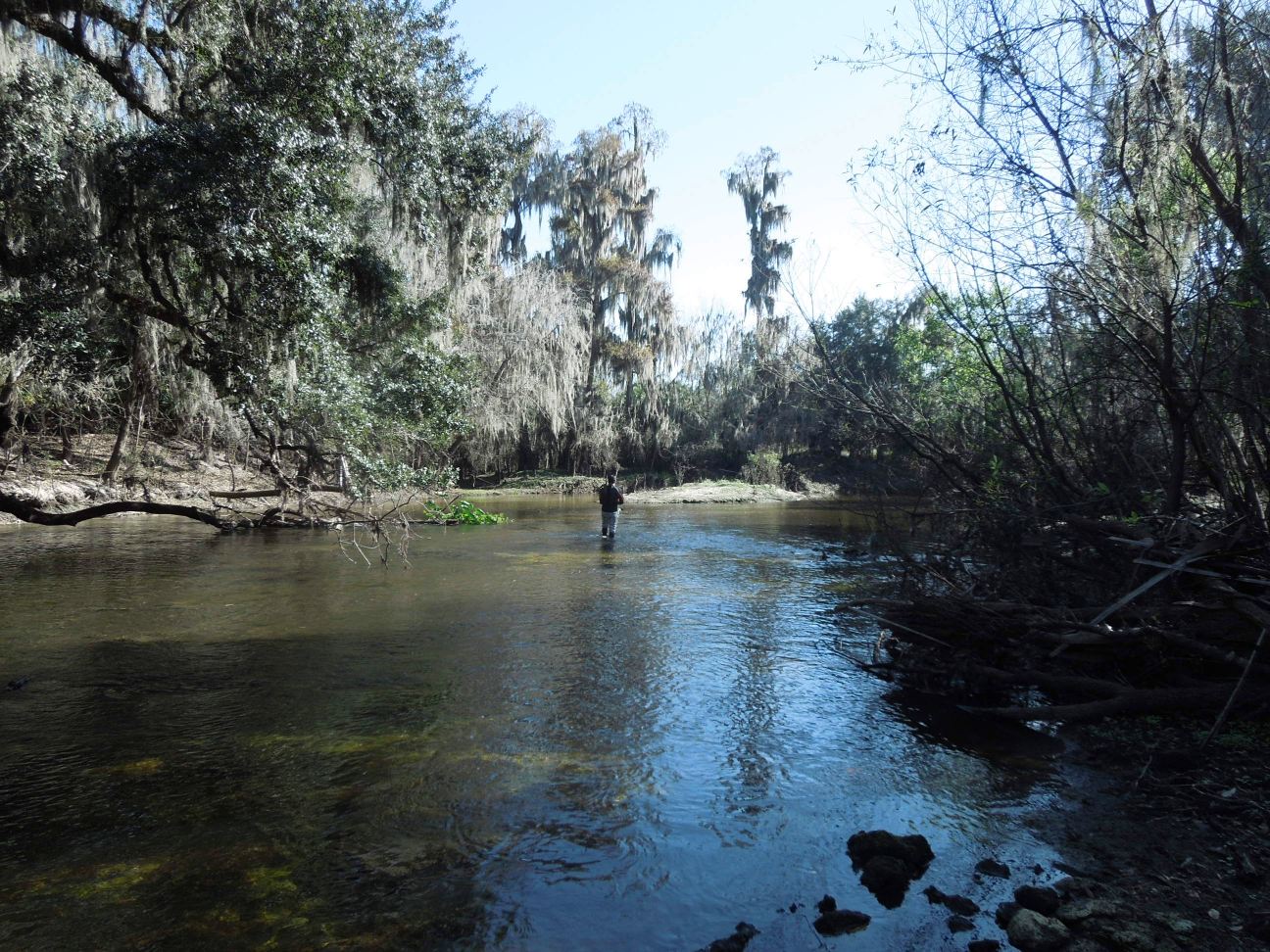
When this water runs shallow over rocks or pale-colored sand, it can be transparent like weak tea. This is especially true if the sun is directly overhead and illuminating the water. In places where the water is deeper, it becomes black and opaque. This darkening is enhanced wherever the river is shaded from sun.
Depending on the time day, placement of the sun, degree of sky cloudiness, the depth of the river, and the composition of the riverbed, the water may have good or terrible visibility. This can vary over short stretches. You might be canoeing over sandy bottom that is only inches away from the tip of your paddle, then you go around a bend and the bottom drops away into the darkness and tall trees on the banks block out the sun. The bottom might still be inches away, or you might be paddling over a hole that is ten feet deep. The only way to find out how deep the dark stretches are is to probe the depths with your paddle and see if you can touch the bottom of the riverbed.
The dark water also conceals snags and rocks. Fallen trees and rocky outcroppings are hidden in the murky waters. When the water is higher, one can paddle right over these obstructions without knowing they are there. During fossil-hunting season, the river is very low and this exposes most of the hazards, but creates new ones. Shallow runs through exposed rocks create rapids and eddies, which must be navigated carefully. Other times, the water is too shallow for paddling and one must climb out of the boat and drag it over rocks that are often slick and jagged. It is worth noting that some Florida limestone and chert nodules break with razor-sharp edges, so water shoes are a must when navigating rivers like the Peace.
When the river height is low and the current is slow, it can be a leisurely paddle against the current going upstream. However, there are numerous places where the river narrows or flows over shallow outcrops, and in these places the current will increase dramatically and with little notice. In wider stretches, the current is usually more gentle, but the wind can often work against you, so one must be prepared to get some good exercise when paddling, regardless of which way the current is going. Even the trip downstream with the current requires a measure of awareness to avoid snags and navigate rapids. On some stretches you can leisurely drift and relax, and then on other stretches you need to pay attention and make correct decisions to avoid getting snagged or submerged.

During fossil season (which is generally winter to early spring), the water is cold. It’s not freezing cold, but hypothermia is a real worry. I try to stay dry from my waist up. Having long legs helps in this regard. As long as my core remains dry, I can avoid hypothermia while doing prolonged wading in the cold water. My partner who dives down into the holes wears a rubber wet suit for insulation. This cold water is a boon for fossil hunters because it makes the native reptiles less active. When air and water temps drop, alligators and snakes go into a state of torpor. They are far less aggressive and less interested in humans. One must always be aware of their presence, but the danger of an unprovoked attack is extremely low during the winter.
The Peace river runs approx. 105 miles as the crow flies from Bartow in the north at the source, down to Port Charlotte in south. Taking into account the twists and bends in the river, it is a 150 mile paddle from end to end. The river north of the town Zolfo Springs is considered the “Upper Peace” and below Zolfo to the south is the “Lower Peace”. Fossils can be found along the entire length of the Peace, but the most accessible deposits generally are found on the Lower Peace which cuts through the Bone Valley formation of the Hawthorn geologic group.
To understand the type and composition of the fossil deposits in the area, one must consider the underlying geology. Along the Upper and Middle Peace, the riverbed is exposed limestone with accumulations of sand, clay, and gravel. Down the Lower Peace, the bottom becomes sandier with thicker sediments of clay and sand. At all points, there are limestone boulders and outcroppings that cut through the banks and riverbed. The banks on all stretches can vary between tall sandy bluffs to low rocky beaches. The banks in areas of interest to fossil hunters occur along undeveloped stretches of the river where the layers of the banks are eroding into the river. These layers alternate between Miocene, Pliocene, and Pleistocene time periods when Florida alternated from being completely underwater (Eocene, Miocene, early Pliocene) to being above water in the late Pliocene to Holocene. Because these layers are laid down in succession, it is possible to find marine Miocene animals like Megalodon shark side by side with Pleistocene megafauna like Mammoths.
By carefully examining the banks and riverbed, one can determine which spots might be worth hunting for fossils. In some cases, the fossils can be seen eroding from the banks. It’s not unusual to find a bone or tusk sticking out of the bank or laying on the bank at water level. In other cases, the fossils have accumulated in holes at the bottom of the dark river below the banks. Bends in the river, tree snags, and rapids also tend to trap and accumulate fossils. The presence of large gravel can also be a sign of fossil deposits nearby or transported by flood action. Heavy mineralized fossils tend to accumulate with gravel, phosphate pebbles, and limestone rocks to build gravel beds on the river bottom. These gravel beds can be productive if one doesn’t mind shoveling and sifting – which can be tricky underwater with a current flowing over your shovel.

Another fossil clue to look for is shelly layers exposed in the sandy riverbanks. There are Miocene-Pliocene layers that are fossil-rich with marine fossils from the period when Florida was completely under water. The Bone Valley formation that the Peace cuts through has some of these deposits near the surface where they are exposed by the course of the river. You can see these layers if you look closely – they are a stark white line that runs between tan sandy layers and grey clayey layers. The presence of this white shelly layer guarantees the presence of Miocene marine invertebrates, and often contains Miocene vertebrates like Megalodon. These shelly layers are the source of most Megalodon teeth found in the Peace. They erode out of the banks, fall into the river, and are transported downstream where they collect in gravel beds, holes, and rapids. Teeth that are freshly exposed from the banks tend to have lighter and prettier colors. The teeth that have been submerged in the tannin-rich waters are stained dark black over time.

Generally speaking, the Lower Peace is more developed and populated than the Upper Peace. Although there are occasional homes and farms along the river, there are also long stretches that are completely undeveloped and surrounded by pristine wetland wilderness. It is these undeveloped stretches that are the most productive for fossil hunting – both because the land is less disturbed, and there is less human traffic in the area (hunters, fishermen, boaters, other fossil hunters, etc).
The stretches we hunt for fossils are largely uninhabited, except for occasional fishermen or kayakers passing through. These stretches are usually too shallow for any boat larger than a canoe or kayak, so you never see large motorboats or airboats in these areas. If you go further south to Gardner on the Lower Peace, airboats and loud bassboats are increasingly present and annoying. Although these annoyances do little to deter meaningful fossil-hunting, it ruins the atmosphere and serenity for folks like myself who enjoy the silence and immersion in nature. One can generally avoid these situations by staying far away from the nearest public boat ramps. While there are public access boat ramps dotted along the length of the Peace, there are also remote stretches that are miles away from the nearest ramps – these areas have a lot less traffic, people, litter, noise, and other signs of humans. In the quiet and pristine areas, it is very easy to forget that one lives in modern times and one gets a feel for what it must have been like centuries ago before man intruded on the Peace.
There are numerous small creeks that feed into the Peace and some of these creeks are good for fossil hunting. However, many of these creeks extend inland into private property where hunting is not allowed without permission from the land owner. So, one must consider and navigate these creeks with a measure of caution and awareness that is not entirely necessary if one sticks to the main river. While we have hunted some of these creeks, we have not had good luck with them and have made very few significant finds in these creeks. Creeks of interest include Charlie Creek, Payne’s Creek, Bowlegs Creek, Whidden Creek, Joshua Creek, Shell Creek, and dozens of smaller, unnamed tributaries.
Flora and fauna along the Peace are plentiful. Common sights include alligators, turtles, wading birds (cranes, egrets, etc), raptors (hawks, eagles, etc), snakes, deer, wild pigs, otters, and the occasional coyote. All of these animals live in the wilderness that surrounds the river and the shy species make their presence known with tracks and calls. Alligators are a constant in all sizes from babies up to 12-foot maneaters. In colder weather, they are very lethargic and do not pose a threat. They lie on the banks soaking up the sun and have little interest in the humans passing by. Snakes are also a constant presence, with the predominate venomous species being cottonmouth (water moccasins), rattlesnakes, and the coral snake. Again, in the cold months, these snakes present little threat, but one must be aware of them when flipping over rocks and reaching into holes.
The predominate vegetation in most areas are the bald cypress tree, various pines, assorted palms, scrub oaks, and palmetto bushes. Vines and wildflowers are also present and provide a pleasant injection of color into the landscape when they are blooming. One favorite of mine was a big mound of Moonflowers that would greet us in the morning as we paddled away from the boat ramp.
For practical matters, it is important to note that cellular service is spotty in the more remote areas. Cell phone service is 3G at best with only one bar of reception if you are lucky. Service is more reliable closer to towns and near the parks with boat ramps, but once you go a few miles down the river into the boonies, your cell service diminishes rapidly. If you have an emergency while out on the river, don’t rely completely on your cellphone. In most cases, first responders or rangers would have a difficult time locating and reaching you. There are no roads to these areas, no place to land a helicopter, and the river is too shallow for Marine Patrol or Game Warden boats. You are literally “on your own” when exploring many of the areas on the Peace.
(End of Part One)